Habitats of America's WETLAND
CHARACTERIZATION OF THE HABITATS OF COASTAL LOUISIANA
There are nine distinct habitats that exist in the Louisiana coastal plain. Each of them is distinct and can be readily identified by its flora (not always by unique species present, but more by combinations and abundance of species. The three driving forces that determine the presence of one habitat over another are:
1. salinity 2. elevation 3. soil type
CHARATERISTIC VEGETATION OF
LOUISIANA COASTAL MARSHES ¹ ²
Marsh Type
|
|
|
|
|
|
|
|
|
|
|
|
|
|
|
|
|
|
|
|
|
|
|
|
|
|
|
|
|
|
¹ from Chabreck, Robert H. 1972. Vegetation, water, and soil characteristics of the Louisiana coastal region. L.S.U. Agricul. Exper. Sta. Bull 664:1-72
² only species covering over 5% of the habitat are listed
³ each with at least 0.01% representation, totaling to 100%
* ppt=parts per thousand
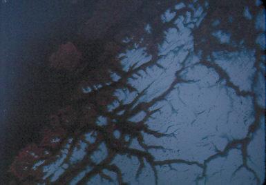
Drainage is very important in the determination of what type of wetland occurs where. A few centimeters elevation is more critical in the coastal wetlands than hundreds of meters are in the mountains.
For our discussion, we will focus on the Barataria Basin (most of the information is from Bahr and Hebrand, 1976). This area is located south of New Orleans, east of Bayou Lafourche and west of the Mississippi River. It is considered by many to be the most productive basin ecosystem in the United States. In Louisiana, it produces 30% of the crab fishery, 27% of the shrimp fishery, and 47% of the menhaden crop.
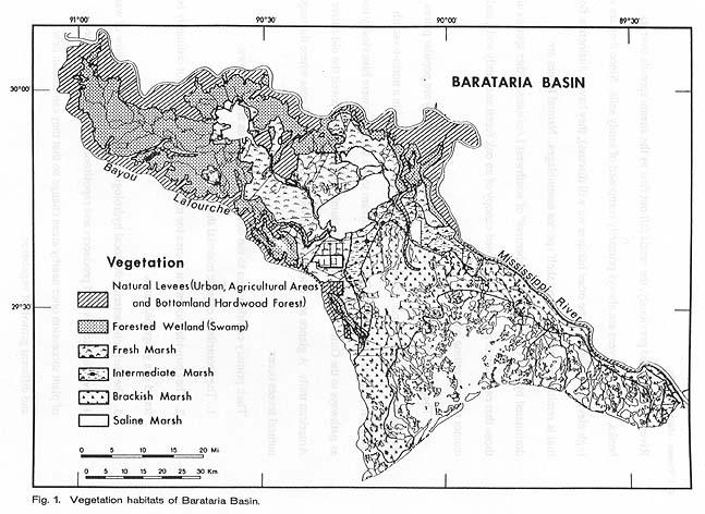
From Bahr and Hebrand (1976)
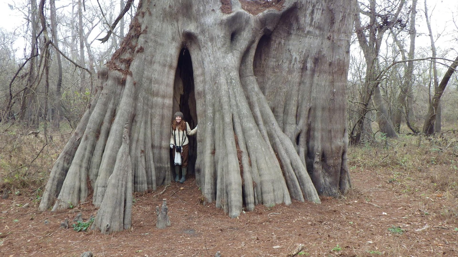
Largest Cypress east of the Mississippi River & Dr. Aimee Thomas – Cat Island NWR above
St. Francisville, La.
VALUES OF LOGS AND BRANCHES IN WATER (the numbered text is taken verbatim from a brochure advertising a new book about the values of wood in water, such as logs in rivers, on beaches, in ponds, etc.). This applies to fresh and salt water.
When we see a turtle sitting on a log in the water, we tend to focus on the turtle and not think of the value of the wood that is immersed in the water.
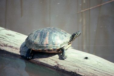
In reality, the wood is performing an incredibly important function in the aquatic/marine ecosystem.
1. Wood in streams and rivers is a source of food energy for invertebrate organisms; habitat for vertebrate organisms, such as fish; and a structural component that shapes, diversifies, and stabilizes channels while helping to dissipate the water's energy before it can scour channels.
2. Wood in estuaries is a major source of food and habitat for obligatory, wood-boring, marine invertebrates which in their feeding break it down and pass usable carbon into the water's current, where it enters the detrital-based marine food web.
3. Wood along the coastline stabilizes sand spits, beaches, and dune complexes, as well as battering rocky shores, where it creates new habitats for intertidal organisms and provides small splinters of wood to the coastal food chain.
4. Driftwood floating in the open ocean attracts a variety of marine invertebrates and fishes, forming a floating surface community that help organisms colonize new areas. Large fishes, such as tuna, not only feed on smaller fishes attracted to the wood but also drift with it because its movement is controlled by wind and current; thus tuna find the bet feeding areas -- current interfaces rich in food species.
5. The loss of wood to aquatic ecosystems means destabilization of streams, estuaries, dunes and beaches as well as food chains in the oceans of the world. Sooner or later it may mean the loss of jobs and unique cultural ways of life, such as the commercial fishing of certain species.
VI. SALT MARSH
Soils are 10% clay and 90% organic matter. There is no organic litter around the plants due to daily flushing from the tides. Fine debris builds and creates an anaerobic environment. Microbes produce methane, hydrogen sulfide, and ferrous compounds that stink to pooyi when you walk through the salt marsh.
Most elements are about the same as the other habitats; heavy metals are lower due to the decreased clay content.
HOW DO PLANTS LIVE IN SALT WATER?
This is the least diverse of the habitats, primarily due to the twice daily flushing that creates the extremes of dry and salty. 63% of the vegetation is one species, oyster grass (Spartina alterniflora). This species is well adapted for the salt environment due to the following characteristics:
1. It has the ability to concentrate salt in cells at higher concentrations than sea water, so it maintains a balanced osmoregularity.
2. It can excrete excess salt.
3. It has air tubes that take oxygen from the leaves to the roots.
Oyster grass can tolerate low salinity, but it has less competition in salt water.
There are four very important positive values to oyster grass:
1. It has dense roots that inhibit erosion. In fact, it produces more biomass below the surface than above.
2. It acts as a nutrient pump. Its roots pull phosphorus out of the anaerobic mud to the surface.
3. Through death, it supplies the estuaries and the Gulf of Mexico with nutrients.
4. It provides important habitat for many critters.
Oyster grass is replaced at 5 cm above mean high tide by S. patens and D. spicata. So, just 5 cm in elevation changes the whole look and feel of coastal marshes.
WHAT IS THE EDGE EFFECT AND WHAT IS AN ECOTONE?
The edge effect (increased diversity found at the interface of two habitats) was studied in this habitat. It was found that, at the edge of the estuary, biomass of the primary consumers was 0.003 lb/sq ft. At 10 ft from the edge in the grass, it was 0.008 lb/sq ft. It gradually declined away from the water's edge to about 0.001 lb/sq ft.
Note: A place where two habitats overlap is called an ecotone. In an ecotone, the edge effect may (actually, usually) happens.
Most primary consumers are found in the edge; only the periwinkle is somewhat evenly distributed.
VII. ESTUARIES.
Definition: An estuary is a semi-enclosed coastal body of water that has a free connection with the open sea and within which seawater is measurably diluted with freshwater derived from land drainage.
Estuaries may be very unstable in salinity depending on riverine input. There are 900 individual estuaries along the U.S. coast, making up 68,000 sq km.
Types of estuaries:
-Fjord - rocky coasts; created by glaciation. Norway, Alaska, northwest Canada.
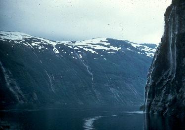
Geiranger Fjord, Norway (photo by R. Fortenberry)
Fjords of Norway
-Fault block estuary - created by geologic changes where there is tectonic activity. San Francisco Bay.

-Coastal plain estuary - flooding of a river valley. Chesapeake Bay via sea level rise of the Holocene.

Delmarva Peninsula, with the Chesapeake Bay to the right.
-Coastal lagoon - behind barrier islands. Gulf coast.
Isles Dernier, Louisiana (May 1993)
Coastal lagoon estuaries of South Texas.
-River delta estuary - at the mouth of a river. Mississippi River estuaries (Pontchartrain, Barataria).
SALINITY
We know that ocean/sea water is 35 parts per thousand (ppt) of salts. Salinity is primarily caused by the presence of sodium and chlorine (86% of sea water). If you add sulfur, magnesium, potassium, and calcium, it adds up to 99%.
|
|
|
|
|
|
|
|
|
|
|
|
|
|
|
|
|
|
|
|
|
|
|
|
|
|
|
|
|
|
|
|
|
|
|
|
Because seawater is usually well mixed, relative proportions of major elements change little. Thus, determination of the most abundant element is a good index of the amount of salt present in a given volume of seawater.
Salinity in estuaries is extremely variable due to:
a. tides
b. effluent of the river
c. winds
Vertical salinity:
a. may have saltwater wedge
b. if good currents, may have no vertical stratification.
Horizontal salinity:
a. freshest water near the river
b. most saline water near the sea
c. A deflection affect is frequently present. Due to the turning of the earth (Coriolis effect), rivers in the northern hemisphere deflect to the right (as they enter the ambient water), so the freshest water is there and the most saline water is to the left.
The amount of freshwater inflow is very important. Mesquite Bay is located on the central Texas Gulf coast. During the 1950s, there was a lengthy drought and salinities ran 35-50 ppt. In early 1957, heavy rains caused salinities to drop to about 2.5 ppt in just two months.
Hypersaline estuaries may result when 1) the inflow of freshwater is low, 2) tidal amplitude is low, and 3) evaporation is high. Laguna Madre in coastal Texas gets as high as 60 ppt. By comparison, Great Salt Lake ranges 140-280 ppt.
PRODUCTIVITY
Productivity is very high in estuaries due to the following:
1. Estuaries are nutrient traps.
a. Benthic critters are rapidly recycling nutrients.
b. High formation of detritus and organic materials.
c. Recovery of deep sediment nutrients by microbial activity and penetrating roots.
2. Diversity of producers. All are present: macrophytes, benthic microphytes, and phytoplankton.
3. Water circulation. The constant movement of estuary water, back and forth, provides work to carry waste away and to move food about. This saves metabolic expenditure of the fauna and allows for the increase in number of sessile critters (those that sit in one place, like oysters, clams, sponges, etc.). The water movement also circulates nutrients and organic matter. Salt water wedges moving under freshwater do so, as well.
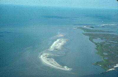
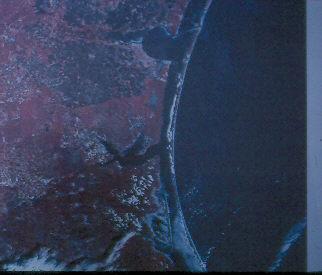
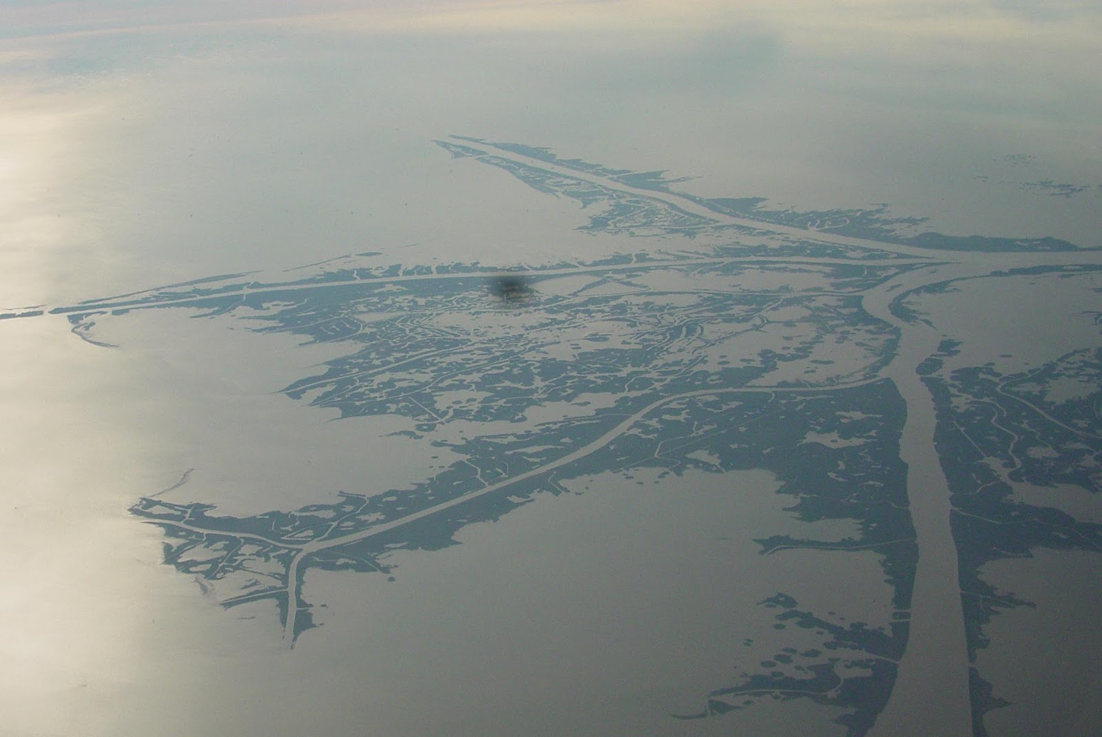
VIII. BARRIER ISLANDS.
These are long, sand (often in dunes) covered islands that are roughly parallel to the coast and separated from the mainland by a lagoon (open water between a barrier island and the mainland) or salt marsh.
Barrier islands are certainly characteristic of the northern Gulf of Mexico, but they don’t occur everywhere – though there are many sites around the world where the do.

Barrier islands are abundant, but not everywhere.
How are they formed?
This theory, called the "cyclic model of deltaic change" (we will call it the "Penland Model" [see below]), expressed the belief that barrier islands were left after the land behind them sank under water due to sea level rise. Hoyt (1967) reasoned that this was true because no marine organisms or their remains are found on the mainland side of the lagoon, so there must have been broad expanses of beach that were covered.
Our own Dr. Shea Penland, University of New Orleans, believes that this is how Louisiana's barrier islands formed. They were once sandy beaches along the leading edge of extensive subdeltas of the Mississippi River. As the river changed course and the subdeltas lost their source of nourishment, the marshes began to subside and left the barrier beaches standing in the open sea as barrier islands.
Lateral view of the Penland Model.

Aerial view of the Penland Model.
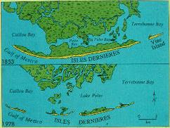
In action: 1853 to 1978.
What causes the migration of barrier islands?
- Waves remove sand from beaches during storms and deposit it offshore.
This sand is usually put back on the beach by natural water movements during the summer. We now help Mother Nature by pumping sand back – at great expense.
- Longshore currents move sand along the beach.
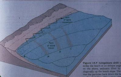
Each time waves mobilize (pick up) sand, the longshore current moves the grains just a little down the beach.
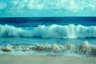
Photo by Carolina Biological Supply.
Eventually, moment-by-moment, day-by-day, the sand drifts farther and farther.
3. Storms and high tides flow over the island and may:
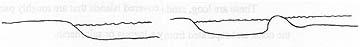
- push sand from the beach front to the rear of the island or, worse, into the lagoon. This is termed an overwash and is clearly visible from the air.

b. cut the island in two by forming a channel.
Isle Derniers, May 1993.
IX. BEACHES AND THE WAVE CLIMATE NEAR THEM.
Definition: A broad ribbon of sand or other sediment (e.g., rocks in Washington state, coral in the Caribbean, lava in Hawaii, ground oyster (grit in southwest Louisiana) lying on the land at the edge of the sea.
Beaches actually belong to the sea since sediments (especially sand) is constantly shifted by waves and longshore currents. They are a river of sand. They are extremely important since they protect marshes from constant wave energy and storm surges.
There is not much available grit or sand near shore in western Louisiana, so most of our beaches are receding.
Plants that characterize the beach:
Mostly evergreen perennials, so there is very little seasonal change. Most of them are xerophytes (plants that tolerate lack of available water) and they typically are very tolerant of disturbance. On the beach proper, characteristic plants include Railway vine (Ipomea pes-capre), beach morning glory (I. imperati), sea oats, cakile, etc.
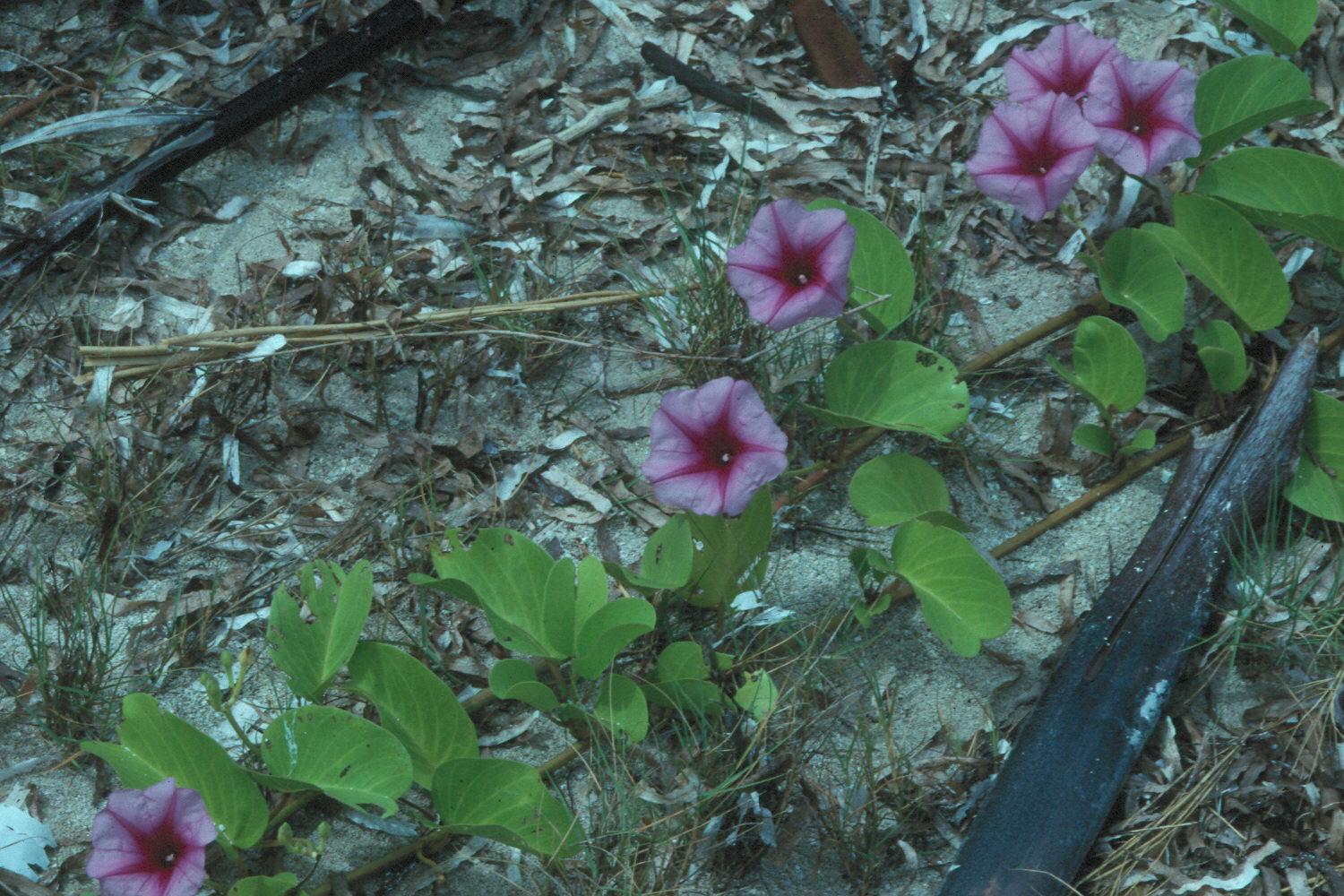
Railway vine Ipomoea pes-capre

Beach morning-glory, Ipomoea imperati
On the beaches of barrier islands, there is an abundant community of detritivores supported by organic carbon that filters down into the sand from the marine waves. The wave action ensures an adequate supply of oxygen. These include especially crustaceans, mollusks, and polychaete worms.
Thixotropy - This allows critters to exploit the surf zone. When sand is covered and/or infused with water, it is very stable until agitated. Have you ever noticed that you can stand in the surf and not sink, but, if you wiggle your toes as the surf runs out, you sink. This is thixotropy. Many beach critters, such a mole crabs, take advantage of this by quickly moving about in the surf with the incoming waves and then, by agitating the sand with their limbs, rapidly disappearing with the outgoing surf. If thixotropy did not happen, fish would eat them immediately.

Standing on the sand flat-footed as the water rushes in. The sand supports your weight.
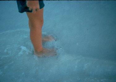
Wiggle your toes.
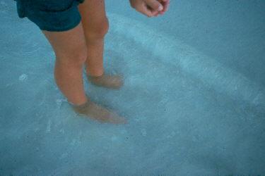
Your feet begin to sink in the “soft” sand.
You continue to sink as long as you wiggle your toes.
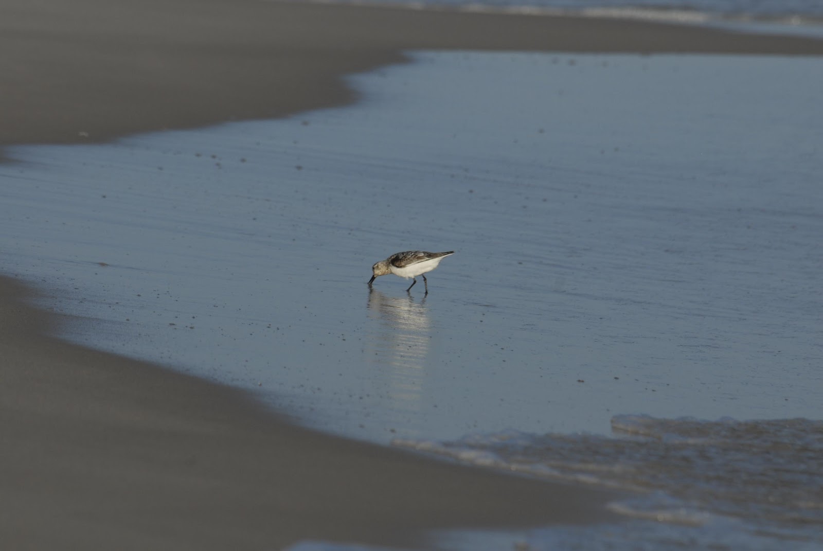
A sanderling using thixotropy to feed in the swash zone.
For the next section, consult the following figure:
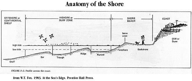
A. Coast - The strip of land affected by the sea, extending landward from the beach to the first major change in terrain. On our beaches, it begins at the seaward edge of the dune field and extends as far inshore as do the effects of the sea. Along a low marshy coast, it is marked by the first permanent land vegetation.
B. Shore, or beach - This is a narrow strip of land in contact with the sea that lies between high and low tide. If composed of loose materials (as our beaches are), regardless of size, they are properly called a beach.
1. Backshore - edge of the coast to the edge of the foreshore (where the beach slants toward to sea). The backshore is horizontal to sloping toward the coast. Berm - flat area of the backshore.
- Foreshore, or beach face - between the backshore and the edge of the sea at low tide; tends to be flatter with finer sands and steeper with coarser materials. When wave action cuts a vertical cliff into the edge of the beach, this is called a beach scarp.
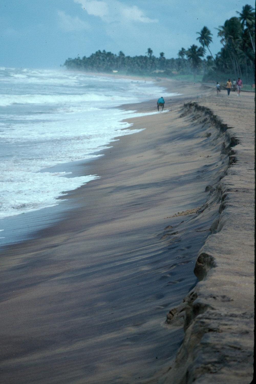
Beach scarp on a Sri Lankan beach.
3. Berm crest - sharp break in the slope between the backshore and the foreshore, if the two can be differentiated.
C. Inshore, or surf, zone - This is located seaward from the foreshore to just beyond the breaker zone. It includes:
1. Longshore bars - these are raised zones of sand parallel to the beach. They remain in the same general area and are never exposed at the surface.
2. Trough - deep area in front of the longshore bar.
3. Ridges - Ridges form in shallow water and are similar in appearance to longshore bars, but instead of remaining in one place they move toward the foreshore. When first formed, they are submerged at low tide; as waves move sand over their leading edge, they slowly move shoreward and a) become exposed at low tide, then b) fuse to the foreshore (a process that takes from days to weeks).
Runnels - deep area between the ridge and the foreshore of the beach.

This photo was taken while standing on a ridge. Note the Navarre, FL, beach to the left, separated from the ridge by a wide runnel. Before this “structure” was a ridge, it was a longshore bar (by definition, under water and not moving toward the foreshore of the beach).

A ridge approaches the beach in Navarre, FL. Note the runnel between the ridge and the beach.

Most of the ridge has coalesced with the beach. Note the beach where the person in the white shorts and yellow shirt is walking. The people ahead of him are wading in the remaining runnel, with another ridge to the right.
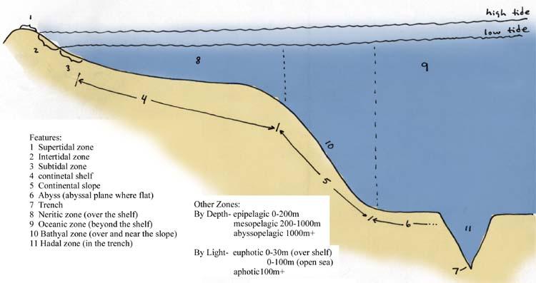
D. Offshore or continental shelf - from the seaward edge of the breaker zone to the edge of the shelf (at about 200 m). Waves affect this area only during storms.
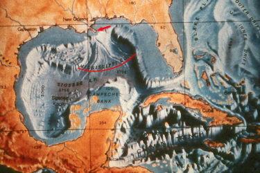
The continental shelf is the “flat” (actually gradually deepening) zone between land and the rapid fall into the abyss of the sea. See the “Features of the Sea” figure below, also.
Surfzone processes - These are governed by:
1. near shore currents - these transport sediment and erode formations.
2. tides - As these change the sea level, they spread the effects of the waves.
- neap tides - lowest highs and highest lows; have the minimum tidal range. These occur when the moon is perpendicular to the plane of the earth and sun

- spring tides - highest highs and lowest lows; maximum tidal ranges. These occur when the moon is on the same plane as the earth and sun and has its maximum pull, in concert with the sun, on the water masses of earth

3. Waves: first, some terminology:
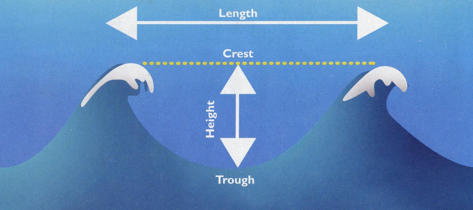
Dive Training, 5/03, p. 28
crest - the top of the wave
trough - the lowest portion on either side of a wave.
height - vertical distance from the crest to the trough.
wave length - horizontal distance from the center of a crest to center of an adjacent crest.
period - time it takes for a wave to pass a point.
Waves crossing the open sea have little effect on the bottom. When water depth (d) is greater than twice the wave length (L), then the wave is considered a deep water wave. When d<2L, then the wave is considered a shallow water (or shoaling) wave (it interacts with the bottom).
As waves move to shore, the period remains the same, but the speed (= phase velocity) decreases due to friction. This causes the wave length to decrease and the height of the wave to increase. As its height/length ratio increases, it becomes more unstable and finally breaks. Each breaking wave releases a bit of its energy. If it crosses several bars, it continually loses energy, so the next breaker is likely to be smaller. They finally wash up on the beach as a flat breaker.
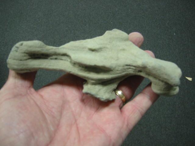
Lithified Sand (Beach Stones or Rock)
These flat sand stones are usually found in coastal deposits (often washed out on the beach front). They are an indication that the beach is eroding and that the spot where they were found used to be the rear of the barrier island. Where do they come from? Lithified sand is formed in washover zones at the rear of barrier islands, at the interfaces of beach/marsh and water/sand. Methane is produced in marsh areas. When the methane reacts with shells in the presence of fine sands, a carbonate cement is formed. This becomes the lithified sand (beach stone or rocks). They are usually irregular in shape, though almost always flat. Holes are usually caused by a plant growing through them or them forming around something that has either fallen or eroded away. These stones may also form as a result of iron interacting with its surrounding environment.


X. OFFSHORE AREAS.
See the adjacent figure "Features of the Sea" for proper terminology for the various zones of the sea.
These areas are greatly affected by organic materials from the estuaries and water and sediment from the Mississippi River (361 billion gal/day).
What causes the richness of the shelf fauna off Barataria and Terrebonne Bays?
1. A freshwater wall, formed by the outflow of the Mississippi River, exists to the southeast and south. Saltwater fish can't penetrate this wall, so they can't emigrate.
2. There are plenty of nutrients being made available from the adjacent estuaries and bays.
3. Since the Mississippi River Delta extends all the way to the shelf, even in the absence of the freshwater wall, critters would tend to focus in this area because species that live over the shelf (such as the commercially important species that we are concerned with: menhaden, shrimp, redfish, speckled trout) do not venture into water beyond the shelf.
HYPOXIC ZONES. Also noted in this area is an occasional expanse of water that is oxygen deficient (a zone of hypoxia). Oxygen deficient zones are correlated with high freshwater discharge and high temperatures. These dead zones, as they have been called, appear to occur when the following combinations of events happen:
1. There is relatively low discharge of freshwater, so there is little turbulence and the discharged freshwater sheets out over the salty sea water and there is very little exchange between the horizontally stratified layers of water.
2. Temperatures are high.
3. Organic material that has washed out of the bays decomposes and consumes oxygen. There is no other source for oxygen since the waters are stratified.
4. The freshwater discharge may (and usually does) contain vast quantities of nutrients (mostly resulting from agricultural run-off of fertilizers). These induce huge algal blooms. These algae either die and consume oxygen as they decompose or they are eaten by zooplankton. Their presence in large numbers will certainly cause the growth of a large zooplankton community. These zooplankton are constantly defecating and dying (if not being eaten by a plankton feeder such as menhaden, manta rays, comb jellies, and the like); these fecal pellets and dead zooplankton settle to the bottom and decompose, thus consuming even more oxygen.
In hypoxic areas, species that can leave do, and those that can't die.

JUBILEES. An interesting occurrence is associated with these events, in the Barataria Basin and, most notably (due to human population density), in Mobile Bay. On occasion, flounder and crabs have been known to come ashore and be so lethargic that they can be scooped up with the hands. This is so exciting that people named these events jubilees. When they occur, no matter what time of day, friends and relatives call and shout, "Jubilee," and everyone comes running with their ice chests. The cause is rather simple. If a dead zone, as described above, forms and an offshore wind blows the surface water away from land, the oxygen deficient bottom water upwells. Normally swimming fish such as redfish and speckled trout simply swim away. If there are bottom dwelling species such as flounder and crabs between shore and the dead zone, they will crawl ashore as the oxygenless water forces them toward land. They are easily picked up due basically to suffocation from the oxygen deficient water that they are avoiding. If you get a chance, don't miss a jubilee!!!
THE ENVIRONMENTAL VALUE OF OIL AND GAS RIGS AND PLATFORMS IN THE GULF.
Of the 1400+ oil and gas related structures in the Gulf of Mexico, 90% are within Louisiana waters. Since the first offshore platform was constructed in 1947 in Ship Shoal (about 12 miles south of Terrebonne Parish), they have been very important in two ways: 1) they recently supplied our nation with 18% of its oil and gas requirements, and 2) they serve as hard structures (in an otherwise soft bottom environment) for reef species to grow (barnacles, corals, and all sorts of other reef animals). The latter, in conjunction with the cover provided, make the structures ideal habitat for all sorts of commercial and sport fish, especially snapper, grouper, cobia, amberjack, and various mackerels.

Since the structures have such value to fisheries, their removal caused concern. Senator John Breaux sponsored the National Fishing Enhancement Act of 1984 to encourage coastal states to establish artificial reef programs. This was followed by the Louisiana Fishing Enhancement Act of 1986 (LFEA) which set the standards for our state's program. It formed the Louisiana Artificial Reef Development Council to give oversight to the program and the Louisiana Artificial Reef Trust Fund (LARTF) to support it. Louisiana Department of Wildlife & Fisheries, in cooperation with the Louisiana Geological Survey and the Coastal Studies Institute (of LSU's Center for Energy and Environmental Research), administers the program.
It has been the responsibility of the oil and gas company to remove the structure within one year of when it completed production. This was normally done by taking the structure to land and dismantling it - a very expensive endeavor. LFEA gave them a new option. They could now scuttle the structures, thus saving large sums of money and retaining the resource. Each company must pay LARTF an amount equal to one half its savings realized by reefing the structure rather than dismantling it.
The deck (the operations part one sees above water) must be removed and moved to shore where it is environmentally safely dismantled so it does not pollute offshore waters. The platform jacket (the portions of the platform extending from the seafloor to the bottom of the deck) is the part that is reefed – dropped below safe levels to rest on the bottom.
Of course, there are controls. There are prohibited areas such as shipping lanes, known commercial fishing grounds, shallow waters, and the like. There are 77 approved sites where this activity can occur, and as of 2019, 402 structures have been placed by the program. The decision of the fate of each structure is taken seriously and not all will qualify for use in the artificial reef program.
The beauty of the program is that everyone wins: we keep the reef resources, industry saves lots of money, and our program is funded without tapping the state's general fund.
We mentioned that 90% of the platforms are on the continental shelf. Virtually all expansion of oil and gas in the Gulf of Mexico is now off the shelf, in thousands of feet of water. The scale of the platforms is unbelievable.

Shell Oil Company platform.

Shell platform superimposed on New Orleans to give a sense of scale.
Of course, these deep water oil platforms make incredible reef habitats, as well.
ANOTHER POTENTIAL WIN-WIN SOLUTION.
At the former Institute of Recyclable Materials at LSU, much research has been done on the use of compressed gypsum blocks, made from gypsum by-product from the phosphate fertilizer industry, as a potential growth substrate for marine organisms. Early success may lead to a solution to our expanding piles of gypsum and the need for growth substrate in the northern Gulf of Mexico, but so far no solutions have been found.